Establishment nearby Yin's Farm
Belize
Establishment nearby Yin's Farm
Yin's Farm
HHFM+G8R, Burrell Boom, Belize
contacts phone
:
+501
Latitude:
17.5738504
, Longitude:
-88.4167457
larger map & directions
read more
nearest Establishment
464 m
BIGGZ BARBERSHOP
HHCP+8GC, Burrell Boom
Establishment
Hair care
Health
Point of interest
read more
826 m
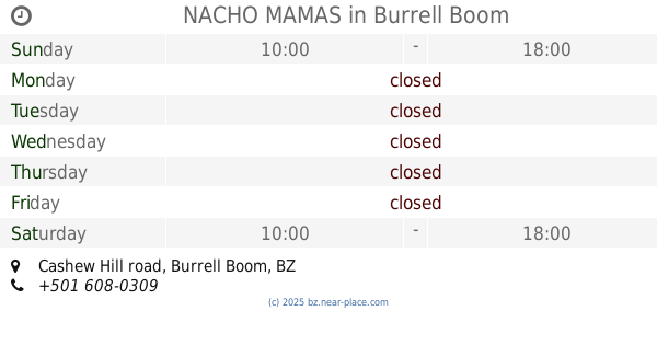
NACHO MAMAS
Cashew Hill road, Burrell Boom
Establishment
Food
Meal takeaway
Point of interest
Restaurant
read more
1.027 km
Elton Gillett Park
HH9R+WQ8, Burrell Boom
Establishment
Park
Point of interest
read more
1.195 km
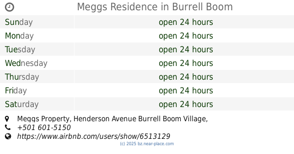
Meggs Residence
Meggs Property, Henderson Avenue Burrell Boom Village
Establishment
Health
Hospital
Point of interest
read more
1.229 km
Paradise Landing
HHGV+7V, Burrell Boom
Establishment
Park
Point of interest
read more
1.331 km
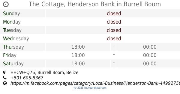
The Cottage, Henderson Bank
HHCW+Q76, Burrell Boom
Establishment
Night club
Point of interest
read more
1.358 km
Burrell Boom Pharmacy
Y Avenue, Burrell Boom Village
Establishment
Health
Pharmacy
Point of interest
Store
read more
1.395 km
Pantojitos
HH8V+RVX, Burrell Boom
Bakery
Establishment
Food
Point of interest
Store
read more
1.598 km
Burrell Boom East Cemetery
HH9W+4QP, Unnamed Road, Burrell Boom
Cemetery
Establishment
Point of interest
read more
1.601 km
Burrel Boom Health Center
HH9W+6RG, Unnamed Road, Burrell Boom
Establishment
Health
Hospital
Point of interest
read more
1.742 km
Eco Beach Rides Golf Carts and Scooters
HH9X+492, Belize City
Car rental
Establishment
Point of interest
read more
1.8 km
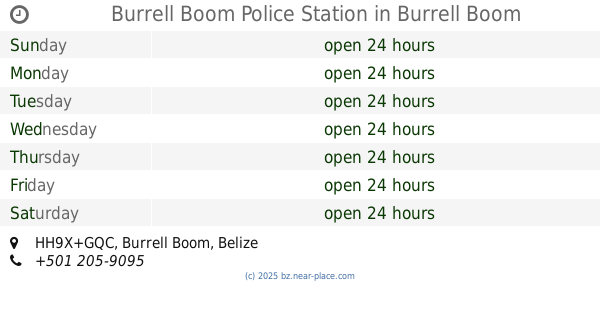
Burrell Boom Police Station
HH9X+GQC, Burrell Boom
Establishment
Point of interest
Police
read more
2.132 km
Kalijay's Frozen Drinks and Treats
HH5V+6WR, Burrell Boom
Cafe
Establishment
Food
Point of interest
Store
read more
2.183 km
Therese's Cafe & Grill
35 Dawson Estate, Burrell Boom
Cafe
Establishment
Food
Point of interest
read more
2.566 km
Rudy Gillett Community Park
HH4X+FG8, Burrell Boom
Establishment
Park
Point of interest
read more
📑
all categories
Accounting
Airport
Art gallery
Atm
Bakery
Bank
Bar
Beauty salon
Bicycle store
Book store
Bus station
Cafe
Campground
Car dealer
Car rental
Car repair
Car wash
Casino
Cemetery
Church
City hall
Clothing store
Convenience store
Courthouse
Dentist
Department store
Doctor
Electrician
Electronics store
Embassy
Establishment
Finance
Fire station
Florist
Food
Funeral home
Furniture store
Gas station
General contractor
Grocery or supermarket
Gym
Hair care
Hardware store
Health
Hindu Temple
Home goods store
Hospital
Insurance agency
Intersection
Jewelry store
Laundry
Lawyer
Library
Liquor store
Local government office
Locality
Locksmith
Lodging
Meal delivery
Meal takeaway
Mosque
Movie theater
Moving company
Museum
Neighborhood
Night club
Park
Parking
Pet store
Pharmacy
Place of worship
Plumber
Point of interest
Police
Political
Post office
Premise
Real estate agency
Restaurant
Route
Rv park, camping
School
Shoe store
Shopping mall
Spa
Stadium
Storage
Store
Subpremise
Supermarket
Taxi stand
Transit station
Travel agency
University
Veterinary care
Zoo
↑