Point of interest nearby BAM'S Catering
Belize
Point of interest nearby BAM'S Catering
BAM'S Catering
Lords Bank Road, Ladyville, BZ Belize
contacts phone
:
+501
Latitude:
17.5491068
, Longitude:
-88.319854
larger map & directions
read more
nearest Point of interest
184 m
Healthy Pet's Veterinary Clinic
HM2H+7WM, Lords Bank Road, Ladyville
Establishment
Point of interest
Veterinary care
read more
541 m
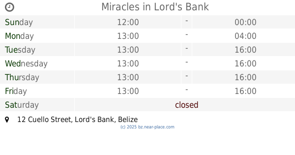
Miracles
12 Cuello Street, Lord's Bank
Establishment
Point of interest
Shoe store
Store
read more
590 m
Lord's Bank Store
HM3M+F63, Lord's Bank Road, Lord's Bank
Establishment
Food
Grocery or supermarket
Point of interest
Store
Supermarket
read more
645 m
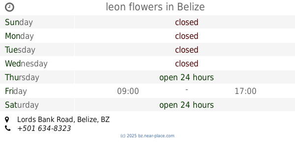
leon flowers
HM2F+GQ5, Lords Bank Road, Belize
Establishment
Florist
Point of interest
Store
read more
661 m
Ming's Happy Store
HM3M+F63, Lord's Bank
Establishment
Food
Grocery or supermarket
Point of interest
Store
Supermarket
read more
663 m
Ms Baked sweetd & treats by mags
75 Lords Bank Road, Belize
Bakery
Establishment
Food
Point of interest
Store
read more
677 m
Allen’s Barbershop
Lord's Bank, 45 Usher Lane, Ladyville
Establishment
Hair care
Health
Point of interest
read more
702 m
Yoli's Katering
GMXP+VMQ, Ladyville
Establishment
Food
Point of interest
Restaurant
read more
734 m
L&Z kitchen
15 myrtle wade cress, Ladyville
Establishment
Food
Point of interest
Restaurant
read more
748 m
Lamb's Family Funeral
231 Lords Bank Road, Ladyville
Establishment
Funeral home
Point of interest
read more
799 m
local Shop
HM3F+8J2, old well Road, Ladyville
Establishment
Home goods store
Point of interest
Store
read more
905 m
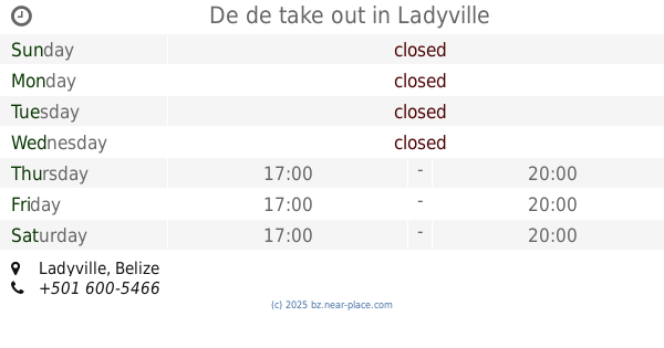
De de take out
Ladyville
Establishment
Food
Point of interest
Restaurant
read more
971 m
Patty's Pastries, Ladyville Meat Pies
HM3Q+49M, Ladyville
Bakery
Establishment
Food
Point of interest
Store
read more
1.114 km
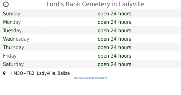
Lord's Bank Cemetery
HM3Q+FR2, Ladyville
Cemetery
Establishment
Point of interest
read more
1.172 km
Vasquez Energy butane service
14 old well road Belize, Ladyville
Establishment
Gas station
Point of interest
read more
📑
all categories
Accounting
Airport
Art gallery
Atm
Bakery
Bank
Bar
Beauty salon
Bicycle store
Book store
Bus station
Cafe
Campground
Car dealer
Car rental
Car repair
Car wash
Casino
Cemetery
Church
City hall
Clothing store
Convenience store
Courthouse
Dentist
Department store
Doctor
Electrician
Electronics store
Embassy
Establishment
Finance
Fire station
Florist
Food
Funeral home
Furniture store
Gas station
General contractor
Grocery or supermarket
Gym
Hair care
Hardware store
Health
Hindu Temple
Home goods store
Hospital
Insurance agency
Intersection
Jewelry store
Laundry
Lawyer
Library
Liquor store
Local government office
Locality
Locksmith
Lodging
Meal delivery
Meal takeaway
Mosque
Movie theater
Moving company
Museum
Neighborhood
Night club
Park
Parking
Pet store
Pharmacy
Place of worship
Plumber
Point of interest
Police
Political
Post office
Premise
Real estate agency
Restaurant
Route
Rv park, camping
School
Shoe store
Shopping mall
Spa
Stadium
Storage
Store
Subpremise
Supermarket
Taxi stand
Transit station
Travel agency
University
Veterinary care
Zoo
↑