Establishment nearby Latitude Adjustment
Belize
Establishment nearby Latitude Adjustment
Latitude Adjustment
Hopkins Back Road, Hopkins, Belize
contacts phone
:
+501 670-1705
website:
latitudeadjustment.bz
Latitude:
16.8521494
, Longitude:
-88.2811542
larger map & directions
read more
nearest Establishment
183 m
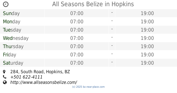
All Seasons Belize
284 South Road, Hopkins
Establishment
Lodging
Point of interest
read more
209 m
AJ Palms Beach Apartments
Hopkins
Establishment
Lodging
Point of interest
read more
212 m
Tipple Tree Beya
Hopkins
Establishment
Lodging
Point of interest
read more
347 m
Roast Coffeehouse
Garimaya, Hopkins
Cafe
Establishment
Food
Point of interest
Store
read more
680 m
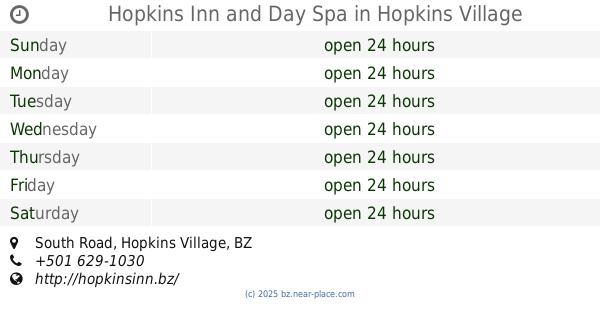
Hopkins Inn and Day Spa
South Road, Hopkins Village
Establishment
Lodging
Point of interest
read more
977 m
Blue Moon Cabana
Hopkins
Establishment
Lodging
Point of interest
read more
1.234 km
Coconut Row Boutique Hotel
Seafront, Hopkins
Establishment
Lodging
Point of interest
read more
1.32 km
Belize Bank ATM
VP78+93V, Hopkins
Atm
Establishment
Finance
Point of interest
read more
1.585 km
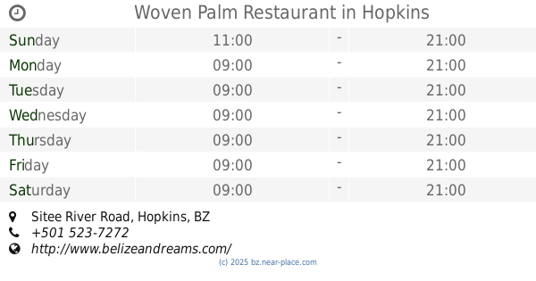
Woven Palm Restaurant
RPRH+96F, Sitee River Road, Hopkins
Establishment
Food
Point of interest
Restaurant
read more
1.638 km
Caribbean Shores Bed & Breakfast
Sitee River Road, Hopkins
Establishment
Lodging
Point of interest
read more
1.651 km
Diversity Cafe & Rental
RPQH+X24, Hopkins
Cafe
Establishment
Food
Point of interest
read more
1.852 km
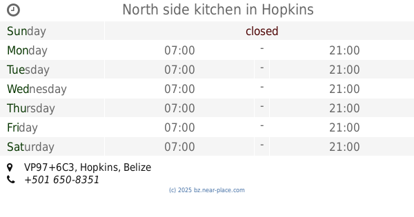
North side kitchen
VP97+6C3, Hopkins
Establishment
Food
Point of interest
Restaurant
read more
1.911 km
Villa Margarita
RPQJ+F2J, Sittee River Road, Hopkins
Establishment
Lodging
Point of interest
read more
2.019 km
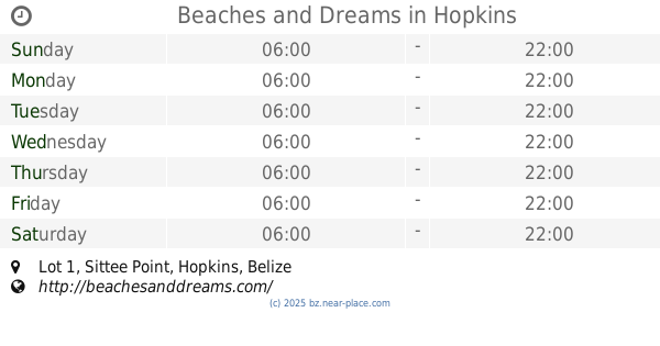
Beaches and Dreams
Sittee Point, Lot 1, Hopkins
Establishment
Lodging
Point of interest
read more
2.199 km
Villa Rising Sun
Phase 1 Lot 14, Hopkins
Establishment
Lodging
Point of interest
Real estate agency
Travel agency
read more
📑
all categories
Accounting
Airport
Art gallery
Atm
Bakery
Bank
Bar
Beauty salon
Bicycle store
Book store
Bus station
Cafe
Campground
Car dealer
Car rental
Car repair
Car wash
Casino
Cemetery
Church
City hall
Clothing store
Convenience store
Courthouse
Dentist
Department store
Doctor
Electrician
Electronics store
Embassy
Establishment
Finance
Fire station
Florist
Food
Funeral home
Furniture store
Gas station
General contractor
Grocery or supermarket
Gym
Hair care
Hardware store
Health
Hindu Temple
Home goods store
Hospital
Insurance agency
Intersection
Jewelry store
Laundry
Lawyer
Library
Liquor store
Local government office
Locality
Locksmith
Lodging
Meal delivery
Meal takeaway
Mosque
Movie theater
Moving company
Museum
Neighborhood
Night club
Park
Parking
Pet store
Pharmacy
Place of worship
Plumber
Point of interest
Police
Political
Post office
Premise
Real estate agency
Restaurant
Route
Rv park, camping
School
Shoe store
Shopping mall
Spa
Stadium
Storage
Store
Subpremise
Supermarket
Taxi stand
Transit station
Travel agency
University
Veterinary care
Zoo
↑