Point of interest nearby Manolo's Tacos
Belize
Point of interest nearby Manolo's Tacos
Manolo's Tacos
s street, Belmopan, BZ Belize
contacts phone
:
+501
Latitude:
17.2447808
, Longitude:
-88.7585681
larger map & directions
read more
nearest Point of interest
448 m
Elda's Fast Food
Parque de Las Americas, Belmopan
Establishment
Food
Point of interest
Restaurant
read more
473 m
Zagga Zowz Kitchen
9 Cayo Street, Belmopan
Establishment
Food
Point of interest
Restaurant
read more
525 m
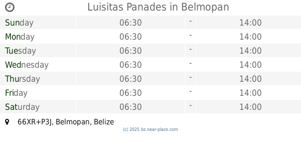
Luisitas Panades
66XR+P3J, Belmopan
Establishment
Food
Point of interest
Restaurant
read more
540 m
Guardian Angel Medical Centre
5 St. Mary Street, Saint Martin Avenue, Belmopan
Establishment
Health
Hospital
Point of interest
read more
559 m
Eve Fusión Cuisine
7 Bethias Lane, Orange Walk Town
Establishment
Food
Point of interest
Restaurant
read more
572 m
The Great Taste, belmopan Belize
30 Guadalupe St, Saint Martin Avenue, Belmopan
Establishment
Food
Point of interest
Restaurant
read more
620 m
Aria's Lounge
Kai'mat St, Belmopan
Establishment
Food
Point of interest
Restaurant
read more
695 m
La Cocina
762R+CC2, 1 Massan, Belmopan
Establishment
Food
Point of interest
Restaurant
read more
695 m
Stephy’s Kitchen & Mainor’s Bar B Que
Kai’mat St, Belmopan
Establishment
Food
Point of interest
Restaurant
read more
773 m
Bubble pop
762R+M7F, Cor. &Guatemala St,Salvapan, City of, Cemetery Road, Belmopan
Cafe
Establishment
Food
Point of interest
Store
read more
800 m
Deisy’s pupuseria
Cemetery Road, Belmopan
Establishment
Food
Point of interest
Restaurant
read more
910 m
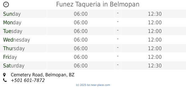
Funez Taqueria
Cemetery Road, Belmopan
Establishment
Food
Point of interest
Restaurant
read more
938 m
Betty’s
5 Nicaragua Street, Belmopan
Establishment
Food
Point of interest
Restaurant
read more
950 m
Desire Restaurant and Bar
37 Half Moon Avenue, Belmopan
Establishment
Food
Point of interest
Restaurant
read more
979 m
GENYSIS MEDICAL LABORATORY
2 Pineapple Street, Belmopan
Establishment
Health
Hospital
Point of interest
read more
📑
all categories
Accounting
Airport
Art gallery
Atm
Bakery
Bank
Bar
Beauty salon
Bicycle store
Book store
Bus station
Cafe
Campground
Car dealer
Car rental
Car repair
Car wash
Casino
Cemetery
Church
City hall
Clothing store
Convenience store
Courthouse
Dentist
Department store
Doctor
Electrician
Electronics store
Embassy
Establishment
Finance
Fire station
Florist
Food
Funeral home
Furniture store
Gas station
General contractor
Grocery or supermarket
Gym
Hair care
Hardware store
Health
Hindu Temple
Home goods store
Hospital
Insurance agency
Intersection
Jewelry store
Laundry
Lawyer
Library
Liquor store
Local government office
Locality
Locksmith
Lodging
Meal delivery
Meal takeaway
Mosque
Movie theater
Moving company
Museum
Neighborhood
Night club
Park
Parking
Pet store
Pharmacy
Place of worship
Plumber
Point of interest
Police
Political
Post office
Premise
Real estate agency
Restaurant
Route
Rv park, camping
School
Shoe store
Shopping mall
Spa
Stadium
Storage
Store
Subpremise
Supermarket
Taxi stand
Transit station
Travel agency
University
Veterinary care
Zoo
↑