Restaurant nearby Katie's
Belize
Restaurant nearby Katie's
Katie's
XQ5F+MM6 Rivas estate area, Dangriga, Belize
contacts phone
:
+501
Latitude:
16.9591741
, Longitude:
-88.2258445
larger map & directions
read more
nearest Restaurant
492 m
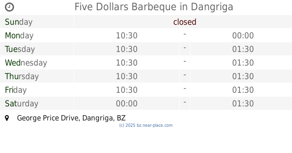
Five Dollars Barbeque
XQ6H+4F2, George Price Drive, Dangriga
Establishment
Food
Point of interest
Restaurant
read more
581 m
Sunlight Restaurant
XQ6H+HJ5, Dangriga
Establishment
Food
Point of interest
Restaurant
read more
636 m
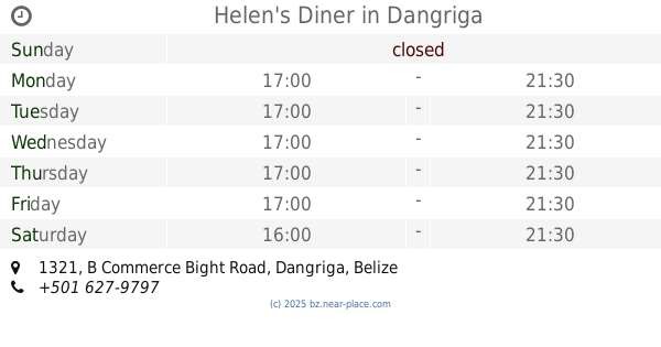
Helen's Diner
B Commerce Bight Road, 1321, Dangriga
Establishment
Food
Point of interest
Restaurant
read more
640 m
LL's Lounge (B-Town)
30 Banak Street, Dangriga
Bar
Establishment
Food
Night club
Point of interest
Restaurant
read more
652 m
Señor Ceviche Bar and Grill
1577 Ecumenical Drive, Dangriga
Bar
Establishment
Food
Point of interest
Restaurant
read more
658 m
Sindiri's Restaurant
XQ7H+2QC, Dangriga
Establishment
Food
Point of interest
Restaurant
read more
670 m
Yummy Yummy
XQ8F+3MH, Ecumenical Drive, Dangriga
Establishment
Food
Point of interest
Restaurant
read more
706 m
Jam Town Takeout
XQ8F+6M9, Ecumenical Drive, Dangriga
Establishment
Food
Meal takeaway
Point of interest
Restaurant
read more
709 m
Kiss Mi Neck
XQ7H+6QG, Main Street, Dangriga
Establishment
Food
Point of interest
Restaurant
read more
751 m
SeaVana Beach Bar and Grill
XQ6J+Q6G, Havana Street, Dangriga
Establishment
Food
Point of interest
Restaurant
read more
752 m
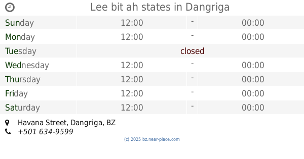
Lee bit ah states
XQ6J+Q6H, Havana Street, Dangriga
Establishment
Food
Point of interest
Restaurant
read more
808 m
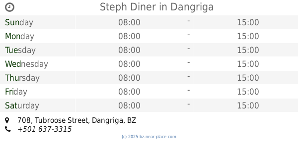
Steph Diner
708 Tubroose Street, Dangriga
Establishment
Food
Point of interest
Restaurant
read more
904 m
Habawabayah Garifuna Restaurant
1734 Southern Foreshore, Dangriga
Establishment
Food
Point of interest
Restaurant
read more
974 m
King Burger
XQ78+RQ7, Dangriga
Establishment
Food
Point of interest
Restaurant
read more
1.212 km
Island Breeze Bar & Grill
Corner of Riverside & Chatuye, Dangriga
Establishment
Food
Point of interest
Restaurant
read more
📑
all categories
Accounting
Airport
Art gallery
Atm
Bakery
Bank
Bar
Beauty salon
Bicycle store
Book store
Bus station
Cafe
Campground
Car dealer
Car rental
Car repair
Car wash
Casino
Cemetery
Church
City hall
Clothing store
Convenience store
Courthouse
Dentist
Department store
Doctor
Electrician
Electronics store
Embassy
Establishment
Finance
Fire station
Florist
Food
Funeral home
Furniture store
Gas station
General contractor
Grocery or supermarket
Gym
Hair care
Hardware store
Health
Hindu Temple
Home goods store
Hospital
Insurance agency
Intersection
Jewelry store
Laundry
Lawyer
Library
Liquor store
Local government office
Locality
Locksmith
Lodging
Meal delivery
Meal takeaway
Mosque
Movie theater
Moving company
Museum
Neighborhood
Night club
Park
Parking
Pet store
Pharmacy
Place of worship
Plumber
Point of interest
Police
Political
Post office
Premise
Real estate agency
Restaurant
Route
Rv park, camping
School
Shoe store
Shopping mall
Spa
Stadium
Storage
Store
Subpremise
Supermarket
Taxi stand
Transit station
Travel agency
University
Veterinary care
Zoo
↑